Friday 21 July 2017

White Paint on Brick


     There's no denying — back in its heyday, Metcalfe Street was one swanky strip of real estate. Now somewhat sandwiched between a pair of apartment blocks, #200 boasted some notable neighbours in the early 1900s. Here's a detail from the Might Directory for 1912, page 114...


     Here, Alfred M. Scott finds himself book-ended by a pair of physicians, not far from a "Sir" and an "Honourable", and a mere pigskin's toss from that well-known local athlete (lacrosse and yes, football) and businessmen (president of Pritchard Andrews Co.), J. Arthur Seybould. And we haven't even looked across the street yet — seriously, someone should write a book.
     That said, I don't think that anyone will be writing a book about Alfred M. Scott any time soon. The man was either mysterious, retired, or both. We can confirm his residence at 200 Metcalfe between 1912 and 1916, but during that time the Might Directories fail to associate his name with any sort of job.

     A gap in my records brings us to the year 1923 but not to any A.M. Scott.  That year appears to show the old Scott house divided into two apartments, with  a Thomas P. Murphy in one, and Herbert and Percy Sims sharing the other — Herbert being listed as another "phys" — Ear, Nose and Throat. Were these houses built over some kind of surgical anomaly?
     A "Heart and Blood Pressure" man moved into the digs in the early '50s and then, in a break with tradition, Thomas Shipman Realtors took over #200 in early 1956. By the 1970s, 200/200a housed a weight-loss clinic and a chiropractors' office. To this day, the building cleaves to its somewhat alternative medical heritage as the address of Advanced Wellness (main floor, "suite 100.")

June 1970 — Ottawa Journal
     
"...Lie on a lounge, bring a book, a sandwich, a martini, or some conversation and a friend..." Here come the seventies!


     I should mention that on the 19th of September 1913, the Ottawa Journal published the following social notice...
Mr. and Mrs. Alfred M. Scott, who have been on an eight weeks' cruise on the Rideau Lakes in their motor boat, The Porcupine, have returned to town.
     It's literally the only sentence I've been able to find that hints at the sort of thing the Alfred M. Scotts did apart from nothing — and bully for them I say!  ;-)

la p'tite maison hantée

Centretown Ottawa — July 2017

An Old Row in the Glebe


     These row houses at 206-212 Queen Elizabeth Drive abut the eastern end of Pretoria Avenue (originally "Jane"). They were built some time between 1901 and 1908, and were originally numbered 560-566 Elgin Street. At some point, each house was divided into small(!!!) upstairs and downstairs apartments.
     City directories date the detached house on the left (214) to some time between 1916 and 1923 — (clearly, I'm not working with a full set.)

adapted from Goad, 1912

     Goad's sheet #147 from 1912 shows our row houses facing east onto Elgin. The little gap between the row and the duplex would eventually accommodate 214 Queen Elizabeth.
     This part of the Glebe was originally a strip of factories and working-class dwellings clustered along the CAR/GTR train tracks, now the Queensway. Notice the "Washing & Wringing Machine" factory on the left side of the plan. Buildings labeled  "lumber shed", "planing... finishing" and "dry kiln" remind us that our modern machines evolved from wooden washtubs. The Pretoria Avenue facility was replaced by a unified one-storey building housing a tile and marble works (DeSpirt early 1947, later Durie). It's now occupied by an animal hospital, a pet groomer and a door-and-window showroom.

Growing pains... February 8 1947, Ottawa Journal

Sunday 2 July 2017

Footprint in a Parking Lot: 196 Lisgar, the Douglas House

     When the snow finally melted this past spring, I got into the habit of cutting through the parking lots between Cooper and Lisgar on my way to Sobey's. I soon noticed the remains of an old limestone foundation poking up from the unpaved ground behind the Queen Elizabeth Apartments* (201 Metcalfe, see here and here).

in the background, the Regency Towers to the left, the Queen Elizabeth on the right (both seen from behind)

     The above photo shows what was the east-side wall of a house, with its front end in the lower right — the yellow line runs along the outside of the foundation.  The heavy masonry (rough measure using my Chuck Taylors**) is about 20" thick. Here's a stitched view of the west wall, excuse the strong distortion...


     The north-west front corner of the house is clearly seen at (1). (2) indicates a small external protrusion, possibly a chimney, incorporates some yellowish stone — sandstone perhaps? (3) is a longer, well-defined protrusion that may indicate a window bay.
     It's notable that the east wall extends exactly 6 Chuck Taylors closer to the street than the west does, indicating an asymmetric facade of the sort we see on so many of the Victorian houses still standing in Ottawa. Indeed, a bit of poking about helps us date the building to the late 1800s.
     Charles Goad's insurance maps make it clear that, as of 1878,  he saw no construction south of Lisgar Street worth documenting. The following decade must have undergone a building boom because by 1888, Goad (and his draftsmen) were drawing little pictures of houses and businesses as far south as Catherine Street and the CAR rail line, now the Queensway.
     Here's an image adapted from Goad's 1888 sheet #52...


     196 Lisgar (top row of houses, second from the left) conforms perfectly with the size, shape and position of our parking lot find. Its solid pink colour indicates solid brick construction, at a prestigious 2½ storeys in height. The grey blocks wedged into the southeast corner of the property are a shed and a stable (the latter marked with an "X" on its roof). The very similar house at 200 Lisgar would be replaced by the Queen Elizabeth apartments at the start of WWII, while at a somewhat later date, 215 Metcalfe would make way for the Regency Towers at 261 Cooper.
     Relying on my meager collection of city directories, I find no 1885 listing for a 196 Lisgar. Jumping ahead to 1901, we find "196 Douglas Clifton A".  Mr. Douglas would reside at #196 until his death in February of 1916, earning the house (I would think) the title of "Douglas House."
     A death is not a cheery thing, but finding an obituary is like finding gold. Here are the nicer things we learn about Clifton Douglas from the Ottawa Journal, February 14 1916, page 4...
     Mr. Clifton A. Douglas, for many years one of the best-known real estate and financial men in this city, died at his home, 196 Lisgar street, on Saturday. Deceased was in his 64th year and had been a resident of Ottawa for the past 35 years.
     Born at Bellefontaine, Ohio, on March [unclear] 1853, the late Mr. Douglas came to Canada to engage in mining in the Ottawa Valley in 1875 and five years later settled here permanently. In that year he established the real estate and insurance business of C. A. Douglas & Co., and about ten years later, the Home Building and Savings Association of Ottawa, of which he has been managing director ever since.
     Deceased was a charter member of the Ottawa Board of Trade and held the office of secretary-treasurer for many years. He was also vice-president of the Copeland, Chatterton, Crain Co. and a director in many other business enterprises in the city.
     As a member of the Scottish Rite and Dalhousie Lodge, the late Mr. Douglas was prominent in Masonic circles, and he was also prominent in benevolent and philanthropic work, being at one time president of the Protestant Home for the Aged and a life director of the Protestant General Hospital.
     In religion the deceased was a Methodist and attended Dominion Methodist church, of which he was a trustee.
     The widow and four daughters, Mrs. W. Muir Edwards, of Edmonton; Mrs. G. F. Reinhardt, of Boston Mass.; Mrs. Kenneth  P. McDonald, of Ottawa, and Miss Marjorie Douglas, of Ottawa, survive him.
     The funeral took place at 3:00 this afternoon from the family residence, 169 [sic] Lisgar street, to Beechwood cemetery, Rev. Dr. Sparling conducting the service.
1906-6-28, Ottawa Journal

      GeoOttawa's aerial photos show the Regency Towers being built in 1965. The Douglas house disappeared some time between that year and 1976.


     In this view from early 1965, the Regency Towers building (RT) nears completion. The morning sun casts a shadow from the northwest wing of the new structure onto the roof of the older, shorter Queen Elizabeth (QE). Notice the construction crane still in place. Douglas House, not yet demolished, sits within the blue circle. Note its complex roof and the "summer kitchen" extension to the rear. "E" indicates the old red-brick house presently being used as the Czech Embassy.
     The Recency Towers began renting in the summer of 1965. Here is an ad from exactly 52 years ago...


     Apartments for rent? What a novel idea!

*I was having trouble getting my head around the idea of calling a building the "Queen Elizabeth" in 1939, when "our" Queen would have been some 12 years old and certainly not yet Monarch. Of course, the apartments were named for the Queen Mother, herself an "Elizabeth." The naming commemorated the 1939 cross-Canadian visit by King George VI and his wife (played by Helena Bonham Carter, best supporting actress) in the same year that Britain declared war on Germany.
The following year, George and Elizabeth would visit the New York World Fair as part of an effort to garner American assistance in "the European War." An intriguing article about a bombing at the Fair (Marc Wortman, Daily Beast) is well worth the read.

**Vans, Nikes,  whatever — each shoe should be 12" long.

Friday 30 June 2017

The Parkdale, Elgin at Gladstone


     The Might Directories indicate that the swank-sounding Parkdale apartment building (first listed as #390-392 Elgin) was constructed around 1912 and that its six rental units replaced two single-family houses of like numbering. Goad 1912 sheet 67 shows this walk-up's brick-veneer-over-wood structure and insists that, because of the indentation created by its Mansard-style roof-line, the Parkdale is a two-and-a-half storey building and not a three.
     Listings as late as 1923 assure us that the Parkdale was not built to accommodate a storefront, but at some point in time that's obviously what happened. The ground floor was gutted, the side windows bricked in, and a projection of what looks to me like 3.5 metres was tacked on to the front of the building. It's been a Mac's for as long as I can remember, not that I've been keeping track. A staircase on the south side of the building permits access to the remaining apartments.
     The Parkdale exudes the charm that comes with peeling paint and a graffiti hit that has persisted unbuffed for at least a year now if not two. The current addresses are 388 Elgin for the store and 390 for the apartments.

Sunny morning, Google Street View — Elgin looking south (L), Gladstone looking west (R)

     This Street View capture shows how far the storefront extends past the original facade. Note the stone foundation and the four bricked-in side windows. The rebuilt balconies take advantage of the storefront roof and may be deeper than the originals.

Sunday 25 June 2017

Early Infill: 404 Elgin, the Holbrook


     According to Kalman & Roaf, (Exploring Ottawa, 1983) the Holbrook dates to 1915 and was designed by the prolific local architect Warner Edgar Noffke. In this case, his clients were Charles and James Holbrook, contractors — the building, one assumes, was conceived as an income property.
     The Might Directories reveal the Holbrook to be an early 20th century example of developer-driven infill. The 1915 directory, reflecting conditions of the previous twelve months, lists 404 and 406 as two detached dwellings, both vacant pending their demolition (and both, it appears, original to the site).  They were very much in the style and size of the adjacent #408, still standing (see Chris Ryan.)
     The following year Might would list the Holbrook at the same address, uniting the two lots and boasting 18 units, all occupied. Dividing this number of apartments by the two original households yields a densification factor of 9x for the property.

Wednesday 21 June 2017

Watch This Space

Click the pic to enlarge — I hate it when you squint.

     To the left of this painterly scene, the distinctive 278 Crichton has found a new admirer, a little red rent-a-potty. Of #278, Katharine Fletcher (Capital Walks) writes...
[It is] a still beautiful 1908 Rogue Victorian red brick home that is a study in competing shapes and forms...  the squared-off central doorway and the balcony alcove [not visible in this shot] are later additions built when the single family home was turned into the Philip Apartments by the Betcherman family in the 1930s.
     In the foreground sits a vacant lot formerly occupied by the Brunswick Apartments at 280 and a modest older house at 282. This 2010 proposal (pdf) for "New Three Storey Stacked Townhouses (32 Units)" gives us a rough idea of what to expect next.

7-9-11 Electric Street


     Timberville.ca, who claim responsibility for this row at the corner of New Edinburgh's Crichton and Electric Streets, describe themselves as offering...
[A]rchitecturally designed, high-quality homes evolved from the classic modernist traditions. Our stunning designs and meticulous finishings ensure consistently spectacular results! Specializing in project management for custom builds and renovations, we take the building experience to the next level. Our current & past projects showcase our beautiful designs in some of Ottawa's finest communities.
     While I'm sure some of the neighbors grumbled when they saw this one going up, they could have been stuck with much worse. Height and setback are well-managed, the exterior reminds us of Sussex Avenue's historic limestone homes (or does a decent job trying) and the graceful upthrust of the columns add the right amount of "classic" to an otherwise modernist design.
     Timberville's website doesn't have much to say about 7-9-11, satisfied to offer a little slideshow and that's about it. This building went up some time after 2011 and demonstrates how modern architecture can (and sometimes does) make effective use of a small lot.
     Younger Ottawans may not realize that as late as the 1970s, parts of the south end of New Edinburgh, especially in the block bounded by Crichton, Electric, MacKay and Beechwood looked a lot like the rougher parts of Lower Town back in the day. If this is progress, I have no great objection.
     This lot was previously the site of 296 Crichton, an old (probably original to the site) flat roofed, red-brick house. A side lawn faced onto Electric. Goad's 1912 reprint shows a two-storey house, built of wood with brick veneer. Some time prior to its demolition, it acquired a boxy-looking front-porch/sun-room addition.
     Note that Crichton appears as "Creighton" in some older documents.

Tuesday 20 June 2017

the Elgin Apartments, #370


     The Elgin Apartments date to the first decade of the 20th century, though pinning down an exact year is a bit tricky. They don't appear in the 1901 Might Directory, but they are listed in the 1909 — without any mention of tenants. This odd state of affairs persists in the 1912 edition. Seven tenants are listed in 1913 while 1914 indicates eight units. This would make two apartments running front to back on each of the above-ground floors.
     The building appears here on Goad's May 1912 reprint, with Elgin Street on the right margin of the page...


     The Elgin Apartments building is at the upper right-hand corner of the plan. Notice the building immediately to its south, numbered 372-376. It predates the Elgin and appears on Goad's 1888 plan (sheet 54), simply labeled 376. Here it's shown as a double storefront, featuring a grocers and a barber shop, with an apartment(s?) upstairs. As best I can tell, this is the same building (today numbered 372) that houses the Elgin Street Diner.
     A curiosity depicted here is the row of six houses that fill out the rest of the block. The two south-most units were unceremoniously lopped off when Gladstone was widened in the early 1960s. The remaining four units were converted to shops and offices — all destroyed by fire on the night of Friday, February 16 1979. As Mike Strobel reported for the Ottawa Journal...


     The "small apartment making up the rest of the block" would have been the Elgin Apartments. #370 had its own brush with fire just two years previous — from an Ottawa Journal photo caption dated January 17 1977...
 "A fireman is framed in the charred window of one of the apartments on the top floor of the nine-unit building at 370 Elgin Street. Fire gutted that floor of the Elgin Apartments at about 10:30 a.m. leaving 40 people without shelter. There were no injuries but damage to the four-storey brick structure was estimated at $30,000."
     The basement of the Elgin Apartments is, of course, home to the most excellent Manx Pub,  http://manxpub.com/ — proudly "TV free since '93."


Monday 19 June 2017

The Lochiel Houses

28 Lochiel, now 244 Frank
 
      Lochiel Street ran west of Elgin for all of one block when the area was first being developed in the late 19th Century — it would eventually become part of Frank Street. Houses on the north side of Lochiel were razed to make way for Jack Purcell Park, more recently a dog park.
     On the south side of Frank, two small Victorian-era houses sit huddled together. Both are at least 130 years old, if the date on the map below is to be trusted. The 1885 city directory lists three households* on Lochiel, but the street numbers are not given.
     #244  (formerly 28 Lochiel) is made of brick, parts of which are veneered with faux masonry, now painted a silvery-grey. Goad calls this a 1½-storey, but I'd give it a two. The mansard-styling on the second storey facade creates the appearance of a tiny, side-gabled house, but the building is actually flat-roofed and at least twice as deep as it's wide.


Goad, January 1888, sheet 54 — Elgin runs along the right margin
 
     Goad shows #s 28 (pink for brick) and 32 (yellow for wood) on the south side of Lochiel. The vacant lot at the corner of Elgin would soon be occupied by The Elgin Apartments (#370 Elgin), eventually, home to the Manx Pub. Both sides of #28 abut the property line, which explains why the current 244 Frank appears glued to the walk-up apartment block on its east flank.

32 Lochiel, now 248 Frank
 
     Built of wood and standing at an uncontested 1½-storeys, 248 Frank is the more modest of the pair. This house is set further back than it's neighbour, allowing it to hide behind a profusion of barely-tamed shrubs. The wooden trim is delightful notwithstanding the loss of a finial, and the vertical siding is plastic — I went up and gave it a poke just to be sure.

*Captain Joseph Reed; H.R. McDonald (caretaker, Model school); Luke Williams (asst. engineer, Normal School)

Tuesday 30 May 2017

Shots of Selkirk

     I left home when I was eighteen, or rather my parents moved to Montreal and asked me if I was coming with them and I said no. I shared, roomed and couch-surfed for two years before renting my own first apartment, a ground-floor bachelor at 50 Selkirk in Vanier. The Selkirk Apartments is a low-rise (five floors, elevator) lurking behind the Eastview Shopping Centre. Back then, rent was $135 all in. That's how long ago.

     I've adapted the map at the top of the page from Belden's 1879 Atlas of Carleton County. It shows Janeville, one of the three communities that would be combined to form Eastview (1908), eventually Vanier (1963), now a part of Ottawa (2001).

     Once upon a time, Selkirk Street was called "John" while Montgomery, the roadway that crosses it at an angle was "Victoria." You can see all of this if you click on the map to enlarge it. If you do, you'll see how John-now-Selkirk runs east from Russell Road (now River Road) to a set of railway tracks labeled "St. Lawrence Ottawa Railroad" — now the Vanier Parkway, a railway no longer.

     I never paid much attention to the east end of Selkirk when I lived there, but I cycled out this past weekend and took a few shots. Some funky little houses there, a couple of which look almost 19th Century.


      103 Selkirk — note the faux masonry treatment. The lintel on the ground-floor window looks like it could be real, likewise the stucco — brick underneath?


     97 Selkirk — and no, it's not you, it's the front porch.


    95 Selkirk — again with the curiously small windows. I've noticed a lot of these latticed enclosures under front porches up in the Gatineaus — a French-Canadian thing? A planting of day-lilies ("hémérocalle") would complete the effect.


     91 Selkirk — more lattice-work, more stucco, and an (added on?) bay window that effectively increases over-all living space while intimidating passing battleships.


     107 Selkirk — balance, simplicity, and finials.


     345 Montgomery, just around the corner from Selkirk —rustic charm hangs on for dear life while Bona's 10-storey office building at 140 Jeanne Mance (2014, SE corner of the Parkway) looms modern in the distance.

Monday 8 May 2017

Bargeboard and Brickwork


   I honestly don't remember taking this picture, let alone when or where. A lovely little house all the same, and lovingly maintained.

Saturday 6 May 2017

306 Metcalfe Street


   "Birkett Castle" was built in the late 19th Century for local merchant and politician Thomas Birkett. The National Trust for Canada explains...
Birkett Castle was the headquarters of the National Trust for Canada from 1981 until 1994. Thomas Birkett, who was an alderman, Mayor of Ottawa, and MP at the turn of the 20th Century, built Birkett Castle in 1896. It is a rare example of Baronial Gothic architecture with towers and a crenellated roofline. Inside it is an attractive home with wood panelling, ornaments, and stained glass windows. Briefly in the 1920s, the building served as the Japanese Embassy and then became the headquarters of the Canadian Boy Scouts Association. From 1961 until 1994, it was occupied by a series of organizations. In 1994, the Government of Hungary bought the building from the National Trust and it has since served as the Embassy of the Republic of Hungary and Residence of the Ambassador.
   Over the decades, the Leda clay so prevalent in this part of Centretown allowed the Castle's foundation to slump unevenly. Cracks developed in the walls of the sun-room facing onto Waverley. This damage was worsened and extended by the earthquake of June 2010. Recent  repairs to the building have entailed the rebuilding of the south-facing foundation using the original masonry.

   A City of Ottawa document describing the house and its repairs can be viewed here. The pdf includes historical discussions as well as photographs of structural damage. The firm of CSV Architects was contracted to provide some beautiful elevation drawings of the Castle.

historical view (n.d.) via the City of Ottawa

   Of the interior, Katharine Fletcher writes (Capital Walks second edition, 2004 Fitzhenry & Whiteside)...
[It] still retains much of its Victorian detailing. Reminiscent of the chinoiserie popular in Victorian times is the vestibule’s pressed-tin panelling figured with oriental designs of birds, dragons, and dolphins. The foyer boasts richly carved wooden paneling. A generous staircase sweeps into the hallway, and a bronze figurine of a fairy, Eau, graces the newel post
   According to Urbsite, "A baronial fantasy piece, 'Birkett's Castle' was designed by architect William Hodgson." You can read about Mr. Hodgson here.

   A modern annex extends westward from the back of the house. While its brick matches the colour of the original structure, no attempt was made to emulate its style, and the annex is not included in the heritage designation.


149-151 Patterson Avenue


    I know, this house looks totally bleak in the rain — but wait until the sun comes out and that hydrangea starts rocking!

   I find no newspaper mentions of Patterson Avenue prior to 1900. Ads from that year announce the sales of "new brick" houses, featuring hot and cold running water! This way to the coal chute boys...

   The City Directories tell us that as of 1901, 149 Patterson was vacant — awaiting its first occupant? Between 1904 and 1923 (possibly both earlier and later), it was the home of George W. Dawson, a purchasing agent for the Department of Public Works.

   Listings up to 1923 treat #149 as a single address. The upstairs would have been converted to a separate apartment some time after that date. Someone did a nice, clean job on the paired front entrances.

   Assuming* a construction date circa 1900, this design respects the basic Victorian layout while manfully eschewing the gracile fripperies of the Queen Anne revival. Solid Edwardian massing is presaged here.

* Jeopardy revived the old chestnut just last night, with Alex Trebek intoning "To assume is to make an ass of 'u' and me." Let's say 1900-1901 is my best guess and leave it at that.

Friday 5 May 2017

3 Third Avenue

 
   This little Spanish Colonial Revival house sits at the east end of Third Avenue, just off Queen Elizabeth Drive in the Glebe. I don't have an exact date (do I ever?) but the style was all the rage from 1915 into the early '30s. The completed building can be seen in aerial photos from 1928.

Thursday 4 May 2017

The Prince Rupert in The Glebe


   The 25-unit Prince Rupert at 585 O'Connor first appeared in the 1915 Might Directory, misidentified as the smaller, older Clifton next door. By the following year, the mix-up had been sorted out and #585 was nearly full.

Hidden in Suburbia

96 Southern Drive, Ottawa

   I was trying to firm up some construction dates for the Rideau Gardens section of Old Ottawa South when I found an unexpected gem — a 1970 article about what could well be the oldest house in the neighbourhood. Indeed, some sources conclude that it's the second oldest homestead in the city.

   The article, written by Gladys Blair, appeared in the Saturday, January 17 edition of the Ottawa Journal.  I reproduce "The Williams House" here in full.

     "When Lewis Williams (who had been a country squire in Cardiff, Wales) set sail for the beckoning wonders of America in 1817, he and his family were bound for Philadelphia. His wife was the daughter of the Earl of Phillips and there were five children, three boys and two girls.
     They were 90 days at sea and the ship. badly battered by Atlantic storms, limped into Quebec City for repairs.
     Here he was persuaded to change his plans. The fertile lands of the newly discovered Ottawa country appealed to him and he decided to establish his new home in Canada instead of the United States.
     With his brother Henry, and William Thomas (Richmond Road). the family arrived in the wilderness of our present Capital in August, 1817.
     At first they attempted to settle near the corner of Lyon and Wellington but found the land too rocky for farming.
     They explored the possibilities of the Sandy Hill district but found it too sandy. By the same token, Lower Town was too swampy. So they ventured southward and finally made a decision.
     Their “chosen land” was Lot K Concession C and included the present Lansdowne Park.
     At this time they were one of the first 10 families in the whole township of Nepean.
     Ten years later, when the Rideau Canal was planned, the Williams were required to give up 100 acres of their land, exactly half of the original grant.
     Lewis Williams the fourth, the remaining descendant, has the deed signed by George IV regarding the expropriation of the land for canal building. It reads:
“At such time as this property fails to be used for canal purposes, it shall revert to the original owner or his heirs.”

     Mr. Williams says his grandfather was just a “growing boy” when he arrived in Canada and that the property was pine and oak forest.
     As the land was cleared, the oak trees were cut and sent out to Montreal and Quebec City and on to England for use by the British Navy in shipbuilding. Mr. Williams, who is now 82 years old, remembers oak stumps in the fields as the land was further developed.
     It eventually became the well-known “Rideau Gardens.”

     The first Williams household was of log and burned about three years after their arrival. The present house, Mrs. Williams says, was built in 1821, a year or so after Braddish Billings had started on his New England-type home on the opposite side of the river [in then Gloucester Township — the Williams property was in Nepean Township, a handful of years before Bytown was established.]
     Built of squared timber and of “barn construction,” the house is little changed since its beginnings. New clapboard covers the old, the front porch is new and the sunporch was added by Lewis Williams the third. The den was also extended to the east about the same time.
     However, the old log walls still remain in the basement and the interior of the house is unchanged.
     A very beautiful staircase ascends to the upper floor where there are five bedrooms.

     As the farm prospered, more and more workers were hired to operate it and the Williams family eventually became wholesale florists.
     When the Second World War began, they were asked by the government to food produce and the farm was converted into a market garden. Many Ottawans will remember the “victory gardens,” which flourished during the war years.
     As many as 110 men were required and, in the summertime, schoolboys were also employed for odd jobs. All the plants were started in greenhouses and Mr. Williams says 50,000 tomato plants were grown yearly, among other vegetables.
     It is interesting to note that there is still a part of Lansdowne Park which belongs to the Williams family. Mr. Williams is not sure of its exact location, but it could be [that] the Rough Riders playing field was former Williams farmland.

     The district where the Williams house still sits, solidly tranquil and beautifully preserved, was finally made into a housing development. It is still called Rideau Gardens, however, in honor of the enterprising Williams family.
     Professor Emmet O’Grady bought the house nine years ago this month [i.e. January 1961] from Mrs. Charles T. Williams, whose husband was the business administrator for the market garden. His brother, Lewis Williams, the only surviving member of the family in Ottawa, handled the farm operation.
     This fascinating family were not only pioneers but have contributed a romantic chapter to the history of Ottawa."
    Rick Wallace has written an account of Lewis Williams and the house at 96 Southern Drive which complements and largely agrees with Ms Blair's. You can read it at the History of Ottawa East website. In a separate discussion, he places the Williams' holdings in the context of historical land ownership and development of the Ottawa East / Ottawa South neighbourhoods.

   Wallace makes reference to an 1828 map drawn up by Col. John By. At times ambiguous (though labeled in a beautifully flourished hand) the map seems to indicate that the Williams land holdings may have well-exceeded 100 acres (possibly closer to 400 at some point in time) and that yes, a good portion of the old Frank Clair Stadium, now TD Place sits on former(?) Williams property.

Sunday 30 April 2017

A Tree Grows in Spenceville

...several, in fact

   Clegg St. marks the southern boundary of Spenceville, now a part of Old Ottawa East. Established 1888, the Spenceville subdivision didn't see much development until 1895, and was largely built up by the 1920s. Newspapers mention Clegg at least as far back as 1923 — an Ottawa Journal  article reveals plans for a proposed OER streetcar line extension with a single-track loop along Main, Clegg, Glenora and Herridge.

   83 Clegg's concrete foundation and square footprint are in keeping with the Craftsman/Foursquare idiom that dated from the 1910s into the '30s, though the house is more modestly scaled and lacks the dormered roof half-storey that often marked the style. Originally, #83 would have looked south toward an expanse of pasture, hay-field and market garden, now the Rideau Garden(s) section of Old Ottawa South. That said, I'm really not sure when this house was built.

   A single-storey, rear-gabled extension was added to the back of the house some time after 1991. A 1931 aerial view seems to show a large broad-leaf tree (elm?) at the edge of the road. If so, the magnificent conifer (spruce? fir?) we see part of in the photo was likely planted after that date.

Saturday 29 April 2017

1886 Rideau Garden Drive


   Rideau Garden Drive borders the left bank of the Rideau River at the north end of Old Ottawa South. It was one of the last strips of land to be developed in that part of the neighbourhood, just before the George McIlraith Bridge was built.

   Constructed in the early 60s, ads for these 3, 4, and 5 bedroom "deluxe custom homes" began to appear in the late summer of 1962 and continued to run into early 1964. The Rideau Garden Drive development featured an assortment of period houses including low-slung bungalows, some with stylishly integrated garages and carports.  Split-levels like the one in our picture were also trending when Uri Gagarin orbited the earth (once!) and JFK sat in the White House.


   Rideau Garden Drive snakes through the middle of this 1965 aerial view — #1886 is circled in red. The McIlraith Bridge appears as a steel skeleton soon to join Main Street to Smyth Road. Materials from the City of Ottawa state that the bridge was "built" in 1964, but if this geoOttawa view is correctly dated, then '64 was at best the date that construction began.

   If there were any trees along the drive, they would have been "landscaped" saplings, nothing larger. Half a century later, Rideau Garden Drive is graced with many mature trees, blending nicely with the wooded shorline.

Wednesday 22 March 2017

The McIntosh, 305 Waverley


   This is one of my favourite Centretown buildings yet I can find nothing about it apart from its name and the fact that it was built in 1927. The name appears in the stained-glass transom window while the  date is blazoned across the "sandstone" escutcheon near the top of the facade.

   I cannot speak to this building's style in any educated way, but apart from being a three storey walk-up, its name conspires with the turret-like bays to evoke something Scottish and solid, though in real life, all that glazing would be hell to protect.

   A few decades ago, a friend occupied the top floor apartment (the one on your left). His front room was the perfect size for an armchair, a footstool, a huge fern in a majolica plant-stand, and a small bookshelf — all blessed with a south-east exposure — indeed, more conservatory than fortress wing.

   I'm guessing that in more genteel times there was a lawn and that people didn't park on it.

190 Lisgar


   This jarring little photo is  testament to what Centretown was and what it has become. Imagine walking through a late 19th century neighbourhood where these 2½ storey brick houses were the norm...

   This (admittedly unflattering) rear view of 190 Lisgar shows us its 1½ storey summer kitchen,  typical of so many simple, front-gabled Victorian houses. These homes were often built using the cheaper brick-on-wood method, more prone to fire and decay — and easier to knock down and replace with something more densified.

   It's a measure of our city's growth that the 1878 Goad maps depicted Lisgar Street as the southern boundary of Ottawa's development for that year. Mr. Goad didn't see fit to include anything beyond, dismissing the area as the marshy hinterland it (mostly) was.

   The 1875 City Directory was more nuanced. A.S. Woodburn did list 16 households on Lisgar's south side — mostly Scottish, a few Irish, mostly "labourers." Woodburn mentioned two carpenters, a carter, a painter, a tailor, a teamster, and a farmer. Three widows were duly noted. However none of these people lived between Elgin and Metcalfe. So yes, you could have indeed looked south from what is now Sobey's onto a miasmatic, frog-festered "beaver meadow."

    A decade-and-spare-change later, Goad's 1888 maps reveal a shift toward more prestigious land use...


   At the top of this detail from sheet 52, the Elgin Street Orphanage exemplifies things institutional. Nine houses command the rest of block 288. Of these, seven are larger, all-brick designs — their footprints bespeak mass and complexity. The two remaining buildings are of more modest size and construction — 190 Lisgar, highlighted in pink, huddles next to its neighbour at 188. 190 is a bit larger up front and boasts a pretty bay window. 188 has the larger summer kitchen and makes do with a broad front verandah. Both houses are shown with long, narrow sheds extending to the very backs of their respective properties.

   Of all the buildings shown here, only two survive. 251 Cooper houses the Czech Embassy while behind it, prim and tidy, is 190 Lisgar, pied-à-terre to Bennett Property Shop Realty. Sometimes, the little house does prevail.

   190 Lisgar would have been built some time between 1875 and 1884. According to the Woodburn Directory for the latter date, the house was occupied by John Robertson, a grain dealer. 


   I haven't had a chance to get a clear shot of #190 from the front — until then, we'll make do with this treatment of a Google Street View capture.

Saturday 11 March 2017

Fair Gorffwysfa From Afar

   In a recent Ottawa Citizen article, Kady O' Malley observes...
It seems distinctly unlikely that Joseph Merrill Currier would ever have predicted that more than a century after his death, he would be remembered not for his exploits in business or politics, but for the house he built as a wedding gift for his bride-to-be – and not even the house itself so much as the address: 24 Sussex Drive...
...There’s not much left of the original Victorian-style villa that Currier christened Gorffwysfa – Welsh for “place of rest” – and the few pictures from that era show the house from a distance, making it difficult to imagine how it must have looked when it was completed in 1868... [emphasis mine, read Ms O'Malley's complete article here.]
   Consider O'Malley's remark — "the few pictures from that era show the house from a distance." I don't know what sort of access was to be had during the 19th century, but rest assured that in the 21st, one does not casually stroll onto the grounds of 24 Sussex, with or without a camera. And then there's that irksome scrim of trees all along the front of the property...

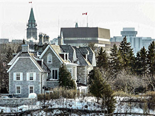
   There is one striking vantage point available to today's photographers, especially those who own a decent telephoto lens. Consider this shot taken by Wikipedia user "Arsenikk."


   Here we see the house atop its limestone bluff, nestled amidst lush greenery, while the Peace Tower and a couple of Canadian flags provide reassuring context. There is only one place i can think of that provides such a view.


   This aerial view of Rockcliffe Park indicates the sight-line (in red) across Governor (Governor's, whatever) Bay, from the Ski Hill lookout to 24 Sussex.

   The Ski Hill lookout sits at 62 metres above sea level (Ski Hill itself rises to just over 66), while ground level at 24 Sussex is 58 metres. So yes, Arsenikk's photo does look downward, ever so slightly, at its subject. By setting his camera as far west as the terrain would permit (I'm guesing he used a tripod) he was able to capture not only the north side of the house but a reasonable glimpse of the rear facade as well.

*     *     *     

   One thing that Ms. O'Malley's article makes clear is that today's 24 Sussex is quite different from the house that Joseph Currier built in the 1800s. The present version may look old, but the building's severe, Romanesque-revival lines actually date to a massive mid-century renovation undertaken in 1950-'51. Currier's original design was smaller and daintier — a Victorian Gothic-revival fairy-castle, bedizened with bay windows and wooden trim, something cozy to charm his new bride.

     A bit of chronology will help us understand the house and what happened to it. Let's start with its builder, Joseph Merrill Currier (1820-1884), who was born in Troy, Vermont, and came to Canada at the age of 17. He found work in the lumber trade and established his own mills in Manotick, New Edinburgh and Hull. He was a federal politician both before and after Confederation and was active in businesses including insurance, publishing and railway. Bankrupted by a sawmill fire in 1878, he bounced back to be appointed Ottawa's Postmaster in 1882. He died two years later and was buried at Beechwood Cemetery. Here are some more dates...
1863-1868 — With the help of his brother James, and during his Parliamentary tenure, Joseph Currier designed and built "Gorffwysfa" for his third wife Hannah Wright, granddaughter of Philemon Wright, the founder of Hull.

1884Joseph Merrill Currier died on April 22. That same year, the Woodburn Directory (Suburban listings, New Edinburgh) shows "Currier Mrs J M, widow, Ottawa n s" — the address signifying "Ottawa Street, north side."

1893 — On August 4, the first electric streetcar ran on Sussex. There was a return stop directly in front of Gorffwysfa. 1894 — On May 3, the streetcar line was extended into the heart of Rockcliffe Park — the park officially opened that same day. Access to the park would continue to improve through to 1900 when the line was extended to the Dominion Rifle Range at the end of Sandridge (now Manor Park.) In November of that year, the first Rockcliffe streetcar barn was built just downhill from 24 Sussex and Rideau Hall. It (the car barn) tended to catch fire. Repeatedly. The relevance of the streetcars to this discussion will become clear soon enough.
Might Directory, 1901
On Janurary 26 1901 Hannah Wright Currier, widow of Joseph Merrill Currier passed away. She she too was buried at Beechwood. Later the same year (or early the next), Gorffwysfa was purchased by the lumber baron and parliamentarian William Cameron Edwards for $30,000. — the 1901 Might Directory lists "Edwards Wm C", not yet moved, still living in Rockland, while the company that bore his name was already well-installed at nearby Rideau Falls.

On March 17 1903, W.C. Edwards was appointed Senator by Sir Wilfred Laurier. Knowing this helps us to date an otherwise undated photo, described as the home of Senator W.C. Edwards.

This is a glass-plate image attributed to William James Topley (1845-1930 "the Man Who Photographed Ottawa"). If nothing else, we can fairly guess that Topley shot this some time between 1903 and 1930 — after which he would have been dead. Knowing this is better than nothing at all.
Topley's early 20th century composition reveals that he faced the same problem that bedevils photographers today — trees. We also know that this picture doesn't quite show Gorffwysfa as Currier designed it because we can see the base of a turret on the left. We are told that Edwards added the turret in 1907 — thus the image dates to 1907 or later.


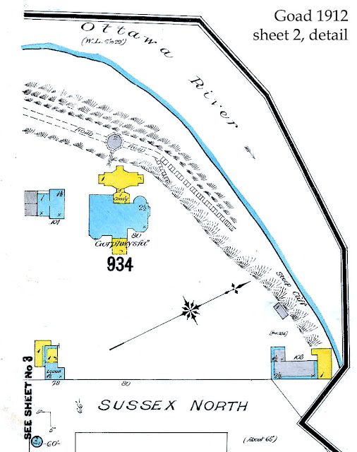
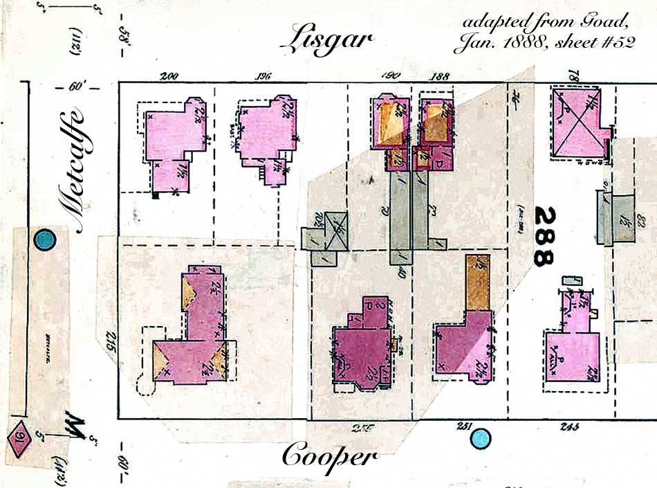
This view of 24 Sussex (then #80 it would seem?) is dated 1912 and gives us an idea of what the property looked like when W.C. Edwards lived there. Note the out-buildings. The "Lodge" to the lower left is now gone. The small stone building next to the main house is actually a shed for the greenhouse that was here, truncated by the edge of the map. (The entire structure appears on Goad's adjacent sheet 3) — the building would ultimately be replaced by the P. E. Trudeau swimming pool.  The L-shaped building to the lower right remains to this day, now used as a gatehouse — its wooden deck, extending past the cliff, has been since removed, probably for the better.  The wooden porte-cochère, supported by stone pillars, is said to have been added at the same time as the turret. I don't know who built the back-yard conservatory, but again I suspect Edwards.

1921 — William Cameron Edwards died on September 17. Ownership of Gorffwysfa eventually (circa 1923) passed to his nephew, Gordon Cameron Edwards, businessman, lumber merchant, and Liberal MP. Gordon Edwards had previously lived at the corner of Charles and Mackay in New Edinburgh.
1943 — from the Ottawa Journal, September 16
"...A claim for $278,697 compensation for the expropriation by the Dominion Government of his Sussex street residence, "Gorphwasfa", has been filed with the Exchequer Court by Gordon C. Edwards. Some months ago the Government filed an offer of $125,000.
The property was first expropriated, according to the Government's explanation, to prevent its being used commercially..."
1945 — from the Ottawa Journal, September 4
"...The former residence of Gordon Edwards, at 24 Sussex street, [was] expropriated this year on [a] ... settlement of $140,000, and reported to be used as the future home of Canadian Prime Ministers or as a guest house for distinguished visitors to Ottawa..." 
1946 — On Saturday November 2, Gordon Cameron Edwards died suddenly at his home, 24 Sussex. The house and its four-acre lot effectively passed into the hands of the Canadian Government. In 1947, Australia assumed a brief lease on the address, to serve as that country's High Commission offices. In 1949, Liberal Minister of Trade and Commerce C.D. Howe announced that the property would indeed serve as the Prime Ministers' Residence after some "refurbishment."
   Thus endeth our chronology.


   The above photo appeared in Maclean's magazine, which in turn credits it to the Ottawa Citizen, 1950, though the actual date of the capture is unclear. Note the wistful Red Ensign drooping in front of the porte-cochère. This is perhaps one of the last, few, clear, close-up views of old Gorffwysfa prior to the great renovation.  It's hard not to love all the sticking-out Victorian bits. One can picture Hannah Currier leaning out from the third-storey oreil, waving a handkerchief and shouting "Yoo-hoo!" to lord-of-the-manor Joseph C. as he paces the front yard,
digesting his dinner. But that was then.
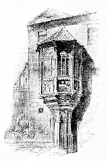
an oreil, Nuremburg

   The renovation (at a cost of nearly half a million dollars — figures vary) was completed in 1951. The new design retained much of the house's structural underpinnings, but the interior was fairly gutted and many of the sticking-out bits were lopped off to achieve an austere, Romanesque (bleakly Norman!) appearance. The house's footprint was extended northward by a two-storey side extension  (which some people call the "east" side — this being Ottawa.)

   It was in this edifice of restrained opulence that Prime Minister Louis St. Laurent took residence. We are told that he was not fully at ease with his sprawling new digs and insisted on paying rent.

almost cozy — even Malak Karsh couldn't get a clear shot
   The rest, as they say, is history. Or rather it was until Stephen Harper moved out in 2015. Some 67 years on, the new, renovated 24 Sussex is old again, sitting empty, cold, and in sore need of extensive and pricey repairs.

 *     *     *

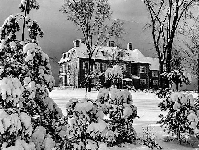
Now is the Winter of our Bleak House, via the National Post
   I'm returning to this POV, as it pertains to three photos from the very early 1900s. Indeed, all the above historical blather has been assembled to provide some perhaps unnecessary context for the charming images which follow.

   James Ballantyne (1835-1925) was a businessman (Ballantyne Coal), local politician and champion of education, often described as the Father of Ottawa East. You can read some biographical notes about this "Renaissance man" here. Ballantyne was an avid naturalist and photographer. Many of his pictures record daily life in and around "Old" Ottawa East, but he also loved to take his friends and family on picnics and nature hikes, camera at the ready.

   It was Kady O'Malley's comment about early images, few and from afar, that reminded me of something I first saw a year or two ago.


   The Library and Archives Canada (LAC) attributes this photo to the James Ballantyne fonds and describes it as a "Group photograph taken during a picnic 1891." The picture would have been taken either by James  himself, or by his daughter Mae.

   We may have to quibble about the date, but the location is beyond question. Anyone familiar with Rockcliffe Park will recognise this as the limestone escarpment overlooking Governor's Bay, with Gorffwysfa perched on its promontory in the upper left of the picture. Ballantyne's picnic crew have been posed partway downhill from the (now) Ski Hill lookout, framed by a break in the trees.

   (And if I've been harping unfairly about the inconvenience of trees, I should mention that some of the Eastern White Cedars growing on these cliffs were already mature trees when Samuel de Champlain's canoes first passed below them in the summer of 1613. Respect is due.)

   Keep your eye on the woman in the dark dress, standing second from the left. We're about to meet her again.


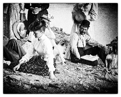
    Here she is, sporting a floppy sun hat. The group has climbed down the escarpment to the beach along the north shore of Governor's Bay. We recognise several people from the previous photo, including the gent with the bowler hat and suspenders, pretending to read his newspaper. I can't quite tell if his gaze is directed at the photographer or toward the young lady in the black hat. The young girl, bottom center, ponders the universe in something round, and someone else has brought an oversized oar that won't be of much use for paddling that canoe.

   Look at the building across the bay — the one on top of the cliff...


 ... 'tis fair Gorffwysfa, seen from afar. If you've noticed that window arrangement of the north facade doesn't match the modern view, that's because the 1950-'51 north extension hasn't been added to the building yet.  I'm not 100% about the smaller building to the right, the one with the dormers set in a mansard roof, but I take it to be the roadside "Lodge" on the southeast corner of the property. This is 24 Sussex as it appeared after Joseph Currier had died but while his widow still lived in the house.

   Now there's a wee cock-up on the dating of these photos. LAC gives a date of 1891 to the clifftop group shot, but sets the beach scene in 1893. A quibble perhaps, but it a bit of question when we consider our third picture.


   Was this an afternoon outing — or a weekend extravaganza?! I count three tents, one pavilion... and a wood stove! Oh, and those oars again. Are they for racing or what? The woman in black is back, seated at the center of the group. And those young ladies are playing lacrosse in the road. The location, to my eye, is halfway down the south-west side of Ski Hill — the curving slope on the left is signature.

   I have no doubt that all three images depict the same weekend outing. But in what year? The date bears on the question of how the bloody hell did Ballantyne haul all those people and all that stuff into the park from his home base at Main Street (just south of the CAR tracks, now the Queensway.) A wood stove for crying out loud...

   The electrified "cars" didn't begin running on Sussex until the first week of August, 1893.  So if the picnic took place in that year, the picnickers could have ridden the streetcars as far as 24 Sussex, then descended on foot into the park by the primitive dirt roads that serviced the area back then. I doubt that they would have taken tents with them, let alone a stove. Those items would have been brought in on horse and buggy, presumably loaded and unloaded by the men. If the picnic was held two years earlier, then everything and everyone was likely brought in by buggy.

   Either way, the woods and cliffs past the end of Sussex were still rather rough around the edges. Still recovering from lumbering and sporting two quarries, a sand pit, a marl pit, a clay pit and, somewhere, a lime kiln, the taming of Rockcliffe would properly begin on a Thursday, May 3 1894, when the park officially opened. That weekend, streetcar service began taking day-trippers from the city into the very heart of woods, where a designated meadow clearing provided refreshments, live music, an electric merry-go-round, and a grassy lawn ready to receive everyone's picnic blankets and baskets.

   James Ballantyne and his crew were either one or three years ahead of the madding crowd. They cooked their own food and made their own fun, roughing it as they saw fit — whether exploring the cliffs, canoeing, reading newspapers, or girl-watching. And Ballantyne was probably the first photographer to take advantage of a sight-line from Rockcliffe Park to 24 Sussex still used to this day.