Tuesday 30 May 2017

Shots of Selkirk

     I left home when I was eighteen, or rather my parents moved to Montreal and asked me if I was coming with them and I said no. I shared, roomed and couch-surfed for two years before renting my own first apartment, a ground-floor bachelor at 50 Selkirk in Vanier. The Selkirk Apartments is a low-rise (five floors, elevator) lurking behind the Eastview Shopping Centre. Back then, rent was $135 all in. That's how long ago.

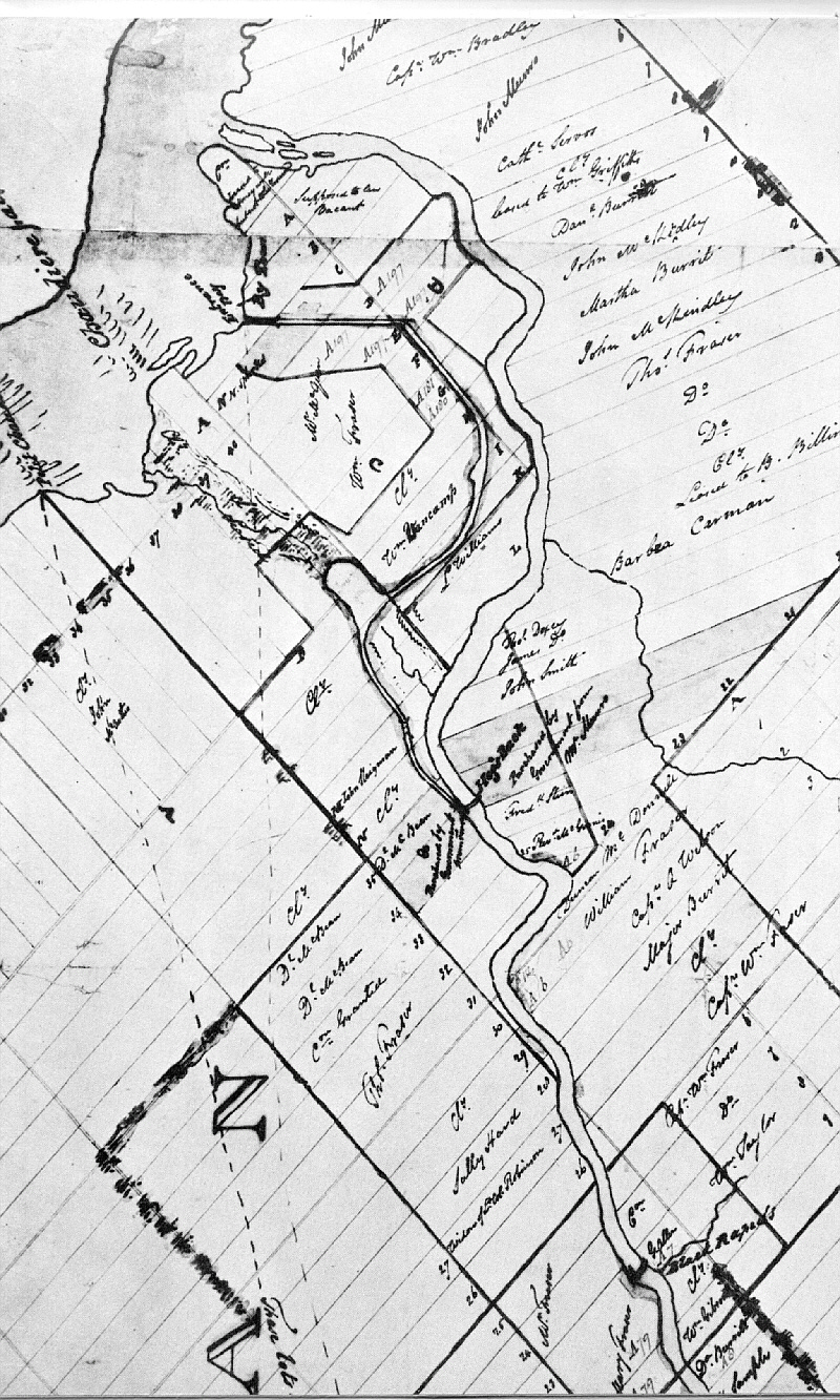
     I've adapted the map at the top of the page from Belden's 1879 Atlas of Carleton County. It shows Janeville, one of the three communities that would be combined to form Eastview (1908), eventually Vanier (1963), now a part of Ottawa (2001).

     Once upon a time, Selkirk Street was called "John" while Montgomery, the roadway that crosses it at an angle was "Victoria." You can see all of this if you click on the map to enlarge it. If you do, you'll see how John-now-Selkirk runs east from Russell Road (now River Road) to a set of railway tracks labeled "St. Lawrence Ottawa Railroad" — now the Vanier Parkway, a railway no longer.

     I never paid much attention to the east end of Selkirk when I lived there, but I cycled out this past weekend and took a few shots. Some funky little houses there, a couple of which look almost 19th Century.


      103 Selkirk — note the faux masonry treatment. The lintel on the ground-floor window looks like it could be real, likewise the stucco — brick underneath?


     97 Selkirk — and no, it's not you, it's the front porch.


    95 Selkirk — again with the curiously small windows. I've noticed a lot of these latticed enclosures under front porches up in the Gatineaus — a French-Canadian thing? A planting of day-lilies ("hémérocalle") would complete the effect.


     91 Selkirk — more lattice-work, more stucco, and an (added on?) bay window that effectively increases over-all living space while intimidating passing battleships.


     107 Selkirk — balance, simplicity, and finials.


     345 Montgomery, just around the corner from Selkirk —rustic charm hangs on for dear life while Bona's 10-storey office building at 140 Jeanne Mance (2014, SE corner of the Parkway) looms modern in the distance.

Monday 8 May 2017

Bargeboard and Brickwork


   I honestly don't remember taking this picture, let alone when or where. A lovely little house all the same, and lovingly maintained.

Saturday 6 May 2017

306 Metcalfe Street


   "Birkett Castle" was built in the late 19th Century for local merchant and politician Thomas Birkett. The National Trust for Canada explains...
Birkett Castle was the headquarters of the National Trust for Canada from 1981 until 1994. Thomas Birkett, who was an alderman, Mayor of Ottawa, and MP at the turn of the 20th Century, built Birkett Castle in 1896. It is a rare example of Baronial Gothic architecture with towers and a crenellated roofline. Inside it is an attractive home with wood panelling, ornaments, and stained glass windows. Briefly in the 1920s, the building served as the Japanese Embassy and then became the headquarters of the Canadian Boy Scouts Association. From 1961 until 1994, it was occupied by a series of organizations. In 1994, the Government of Hungary bought the building from the National Trust and it has since served as the Embassy of the Republic of Hungary and Residence of the Ambassador.
   Over the decades, the Leda clay so prevalent in this part of Centretown allowed the Castle's foundation to slump unevenly. Cracks developed in the walls of the sun-room facing onto Waverley. This damage was worsened and extended by the earthquake of June 2010. Recent  repairs to the building have entailed the rebuilding of the south-facing foundation using the original masonry.

   A City of Ottawa document describing the house and its repairs can be viewed here. The pdf includes historical discussions as well as photographs of structural damage. The firm of CSV Architects was contracted to provide some beautiful elevation drawings of the Castle.

historical view (n.d.) via the City of Ottawa

   Of the interior, Katharine Fletcher writes (Capital Walks second edition, 2004 Fitzhenry & Whiteside)...
[It] still retains much of its Victorian detailing. Reminiscent of the chinoiserie popular in Victorian times is the vestibule’s pressed-tin panelling figured with oriental designs of birds, dragons, and dolphins. The foyer boasts richly carved wooden paneling. A generous staircase sweeps into the hallway, and a bronze figurine of a fairy, Eau, graces the newel post
   According to Urbsite, "A baronial fantasy piece, 'Birkett's Castle' was designed by architect William Hodgson." You can read about Mr. Hodgson here.

   A modern annex extends westward from the back of the house. While its brick matches the colour of the original structure, no attempt was made to emulate its style, and the annex is not included in the heritage designation.


149-151 Patterson Avenue


    I know, this house looks totally bleak in the rain — but wait until the sun comes out and that hydrangea starts rocking!

   I find no newspaper mentions of Patterson Avenue prior to 1900. Ads from that year announce the sales of "new brick" houses, featuring hot and cold running water! This way to the coal chute boys...

   The City Directories tell us that as of 1901, 149 Patterson was vacant — awaiting its first occupant? Between 1904 and 1923 (possibly both earlier and later), it was the home of George W. Dawson, a purchasing agent for the Department of Public Works.

   Listings up to 1923 treat #149 as a single address. The upstairs would have been converted to a separate apartment some time after that date. Someone did a nice, clean job on the paired front entrances.

   Assuming* a construction date circa 1900, this design respects the basic Victorian layout while manfully eschewing the gracile fripperies of the Queen Anne revival. Solid Edwardian massing is presaged here.

* Jeopardy revived the old chestnut just last night, with Alex Trebek intoning "To assume is to make an ass of 'u' and me." Let's say 1900-1901 is my best guess and leave it at that.

Friday 5 May 2017

3 Third Avenue

 
   This little Spanish Colonial Revival house sits at the east end of Third Avenue, just off Queen Elizabeth Drive in the Glebe. I don't have an exact date (do I ever?) but the style was all the rage from 1915 into the early '30s. The completed building can be seen in aerial photos from 1928.

Thursday 4 May 2017

The Prince Rupert in The Glebe


   The 25-unit Prince Rupert at 585 O'Connor first appeared in the 1915 Might Directory, misidentified as the smaller, older Clifton next door. By the following year, the mix-up had been sorted out and #585 was nearly full.

Hidden in Suburbia

96 Southern Drive, Ottawa

   I was trying to firm up some construction dates for the Rideau Gardens section of Old Ottawa South when I found an unexpected gem — a 1970 article about what could well be the oldest house in the neighbourhood. Indeed, some sources conclude that it's the second oldest homestead in the city.

   The article, written by Gladys Blair, appeared in the Saturday, January 17 edition of the Ottawa Journal.  I reproduce "The Williams House" here in full.

     "When Lewis Williams (who had been a country squire in Cardiff, Wales) set sail for the beckoning wonders of America in 1817, he and his family were bound for Philadelphia. His wife was the daughter of the Earl of Phillips and there were five children, three boys and two girls.
     They were 90 days at sea and the ship. badly battered by Atlantic storms, limped into Quebec City for repairs.
     Here he was persuaded to change his plans. The fertile lands of the newly discovered Ottawa country appealed to him and he decided to establish his new home in Canada instead of the United States.
     With his brother Henry, and William Thomas (Richmond Road). the family arrived in the wilderness of our present Capital in August, 1817.
     At first they attempted to settle near the corner of Lyon and Wellington but found the land too rocky for farming.
     They explored the possibilities of the Sandy Hill district but found it too sandy. By the same token, Lower Town was too swampy. So they ventured southward and finally made a decision.
     Their “chosen land” was Lot K Concession C and included the present Lansdowne Park.
     At this time they were one of the first 10 families in the whole township of Nepean.
     Ten years later, when the Rideau Canal was planned, the Williams were required to give up 100 acres of their land, exactly half of the original grant.
     Lewis Williams the fourth, the remaining descendant, has the deed signed by George IV regarding the expropriation of the land for canal building. It reads:
“At such time as this property fails to be used for canal purposes, it shall revert to the original owner or his heirs.”

     Mr. Williams says his grandfather was just a “growing boy” when he arrived in Canada and that the property was pine and oak forest.
     As the land was cleared, the oak trees were cut and sent out to Montreal and Quebec City and on to England for use by the British Navy in shipbuilding. Mr. Williams, who is now 82 years old, remembers oak stumps in the fields as the land was further developed.
     It eventually became the well-known “Rideau Gardens.”

     The first Williams household was of log and burned about three years after their arrival. The present house, Mrs. Williams says, was built in 1821, a year or so after Braddish Billings had started on his New England-type home on the opposite side of the river [in then Gloucester Township — the Williams property was in Nepean Township, a handful of years before Bytown was established.]
     Built of squared timber and of “barn construction,” the house is little changed since its beginnings. New clapboard covers the old, the front porch is new and the sunporch was added by Lewis Williams the third. The den was also extended to the east about the same time.
     However, the old log walls still remain in the basement and the interior of the house is unchanged.
     A very beautiful staircase ascends to the upper floor where there are five bedrooms.

     As the farm prospered, more and more workers were hired to operate it and the Williams family eventually became wholesale florists.
     When the Second World War began, they were asked by the government to food produce and the farm was converted into a market garden. Many Ottawans will remember the “victory gardens,” which flourished during the war years.
     As many as 110 men were required and, in the summertime, schoolboys were also employed for odd jobs. All the plants were started in greenhouses and Mr. Williams says 50,000 tomato plants were grown yearly, among other vegetables.
     It is interesting to note that there is still a part of Lansdowne Park which belongs to the Williams family. Mr. Williams is not sure of its exact location, but it could be [that] the Rough Riders playing field was former Williams farmland.

     The district where the Williams house still sits, solidly tranquil and beautifully preserved, was finally made into a housing development. It is still called Rideau Gardens, however, in honor of the enterprising Williams family.
     Professor Emmet O’Grady bought the house nine years ago this month [i.e. January 1961] from Mrs. Charles T. Williams, whose husband was the business administrator for the market garden. His brother, Lewis Williams, the only surviving member of the family in Ottawa, handled the farm operation.
     This fascinating family were not only pioneers but have contributed a romantic chapter to the history of Ottawa."
    Rick Wallace has written an account of Lewis Williams and the house at 96 Southern Drive which complements and largely agrees with Ms Blair's. You can read it at the History of Ottawa East website. In a separate discussion, he places the Williams' holdings in the context of historical land ownership and development of the Ottawa East / Ottawa South neighbourhoods.

   Wallace makes reference to an 1828 map drawn up by Col. John By. At times ambiguous (though labeled in a beautifully flourished hand) the map seems to indicate that the Williams land holdings may have well-exceeded 100 acres (possibly closer to 400 at some point in time) and that yes, a good portion of the old Frank Clair Stadium, now TD Place sits on former(?) Williams property.