Sunday, 30 April 2017

A Tree Grows in Spenceville

...several, in fact

   Clegg St. marks the southern boundary of Spenceville, now a part of Old Ottawa East. Established 1888, the Spenceville subdivision didn't see much development until 1895, and was largely built up by the 1920s. Newspapers mention Clegg at least as far back as 1923 — an Ottawa Journal  article reveals plans for a proposed OER streetcar line extension with a single-track loop along Main, Clegg, Glenora and Herridge.

   83 Clegg's concrete foundation and square footprint are in keeping with the Craftsman/Foursquare idiom that dated from the 1910s into the '30s, though the house is more modestly scaled and lacks the dormered roof half-storey that often marked the style. Originally, #83 would have looked south toward an expanse of pasture, hay-field and market garden, now the Rideau Garden(s) section of Old Ottawa South. That said, I'm really not sure when this house was built.

   A single-storey, rear-gabled extension was added to the back of the house some time after 1991. A 1931 aerial view seems to show a large broad-leaf tree (elm?) at the edge of the road. If so, the magnificent conifer (spruce? fir?) we see part of in the photo was likely planted after that date.

Saturday, 29 April 2017

1886 Rideau Garden Drive


   Rideau Garden Drive borders the left bank of the Rideau River at the north end of Old Ottawa South. It was one of the last strips of land to be developed in that part of the neighbourhood, just before the George McIlraith Bridge was built.

   Constructed in the early 60s, ads for these 3, 4, and 5 bedroom "deluxe custom homes" began to appear in the late summer of 1962 and continued to run into early 1964. The Rideau Garden Drive development featured an assortment of period houses including low-slung bungalows, some with stylishly integrated garages and carports.  Split-levels like the one in our picture were also trending when Uri Gagarin orbited the earth (once!) and JFK sat in the White House.


   Rideau Garden Drive snakes through the middle of this 1965 aerial view — #1886 is circled in red. The McIlraith Bridge appears as a steel skeleton soon to join Main Street to Smyth Road. Materials from the City of Ottawa state that the bridge was "built" in 1964, but if this geoOttawa view is correctly dated, then '64 was at best the date that construction began.

   If there were any trees along the drive, they would have been "landscaped" saplings, nothing larger. Half a century later, Rideau Garden Drive is graced with many mature trees, blending nicely with the wooded shorline.

Wednesday, 22 March 2017

The McIntosh, 305 Waverley


   This is one of my favourite Centretown buildings yet I can find nothing about it apart from its name and the fact that it was built in 1927. The name appears in the stained-glass transom window while the  date is blazoned across the "sandstone" escutcheon near the top of the facade.

   I cannot speak to this building's style in any educated way, but apart from being a three storey walk-up, its name conspires with the turret-like bays to evoke something Scottish and solid, though in real life, all that glazing would be hell to protect.

   A few decades ago, a friend occupied the top floor apartment (the one on your left). His front room was the perfect size for an armchair, a footstool, a huge fern in a majolica plant-stand, and a small bookshelf — all blessed with a south-east exposure — indeed, more conservatory than fortress wing.

   I'm guessing that in more genteel times there was a lawn and that people didn't park on it.

190 Lisgar


   This jarring little photo is  testament to what Centretown was and what it has become. Imagine walking through a late 19th century neighbourhood where these 2½ storey brick houses were the norm...

   This (admittedly unflattering) rear view of 190 Lisgar shows us its 1½ storey summer kitchen,  typical of so many simple, front-gabled Victorian houses. These homes were often built using the cheaper brick-on-wood method, more prone to fire and decay — and easier to knock down and replace with something more densified.

   It's a measure of our city's growth that the 1878 Goad maps depicted Lisgar Street as the southern boundary of Ottawa's development for that year. Mr. Goad didn't see fit to include anything beyond, dismissing the area as the marshy hinterland it (mostly) was.

   The 1875 City Directory was more nuanced. A.S. Woodburn did list 16 households on Lisgar's south side — mostly Scottish, a few Irish, mostly "labourers." Woodburn mentioned two carpenters, a carter, a painter, a tailor, a teamster, and a farmer. Three widows were duly noted. However none of these people lived between Elgin and Metcalfe. So yes, you could have indeed looked south from what is now Sobey's onto a miasmatic, frog-festered "beaver meadow."

    A decade-and-spare-change later, Goad's 1888 maps reveal a shift toward more prestigious land use...


   At the top of this detail from sheet 52, the Elgin Street Orphanage exemplifies things institutional. Nine houses command the rest of block 288. Of these, seven are larger, all-brick designs — their footprints bespeak mass and complexity. The two remaining buildings are of more modest size and construction — 190 Lisgar, highlighted in pink, huddles next to its neighbour at 188. 190 is a bit larger up front and boasts a pretty bay window. 188 has the larger summer kitchen and makes do with a broad front verandah. Both houses are shown with long, narrow sheds extending to the very backs of their respective properties.

   Of all the buildings shown here, only two survive. 251 Cooper houses the Czech Embassy while behind it, prim and tidy, is 190 Lisgar, pied-à-terre to Bennett Property Shop Realty. Sometimes, the little house does prevail.

   190 Lisgar would have been built some time between 1875 and 1884. According to the Woodburn Directory for the latter date, the house was occupied by John Robertson, a grain dealer. 


   I haven't had a chance to get a clear shot of #190 from the front — until then, we'll make do with this treatment of a Google Street View capture.

Saturday, 11 March 2017

Fair Gorffwysfa From Afar

   In a recent Ottawa Citizen article, Kady O' Malley observes...
It seems distinctly unlikely that Joseph Merrill Currier would ever have predicted that more than a century after his death, he would be remembered not for his exploits in business or politics, but for the house he built as a wedding gift for his bride-to-be – and not even the house itself so much as the address: 24 Sussex Drive...
...There’s not much left of the original Victorian-style villa that Currier christened Gorffwysfa – Welsh for “place of rest” – and the few pictures from that era show the house from a distance, making it difficult to imagine how it must have looked when it was completed in 1868... [emphasis mine, read Ms O'Malley's complete article here.]
   Consider O'Malley's remark — "the few pictures from that era show the house from a distance." I don't know what sort of access was to be had during the 19th century, but rest assured that in the 21st, one does not casually stroll onto the grounds of 24 Sussex, with or without a camera. And then there's that irksome scrim of trees all along the front of the property...

   There is one striking vantage point available to today's photographers, especially those who own a decent telephoto lens. Consider this shot taken by Wikipedia user "Arsenikk."


   Here we see the house atop its limestone bluff, nestled amidst lush greenery, while the Peace Tower and a couple of Canadian flags provide reassuring context. There is only one place i can think of that provides such a view.


   This aerial view of Rockcliffe Park indicates the sight-line (in red) across Governor (Governor's, whatever) Bay, from the Ski Hill lookout to 24 Sussex.

   The Ski Hill lookout sits at 62 metres above sea level (Ski Hill itself rises to just over 66), while ground level at 24 Sussex is 58 metres. So yes, Arsenikk's photo does look downward, ever so slightly, at its subject. By setting his camera as far west as the terrain would permit (I'm guesing he used a tripod) he was able to capture not only the north side of the house but a reasonable glimpse of the rear facade as well.

*     *     *     

   One thing that Ms. O'Malley's article makes clear is that today's 24 Sussex is quite different from the house that Joseph Currier built in the 1800s. The present version may look old, but the building's severe, Romanesque-revival lines actually date to a massive mid-century renovation undertaken in 1950-'51. Currier's original design was smaller and daintier — a Victorian Gothic-revival fairy-castle, bedizened with bay windows and wooden trim, something cozy to charm his new bride.

     A bit of chronology will help us understand the house and what happened to it. Let's start with its builder, Joseph Merrill Currier (1820-1884), who was born in Troy, Vermont, and came to Canada at the age of 17. He found work in the lumber trade and established his own mills in Manotick, New Edinburgh and Hull. He was a federal politician both before and after Confederation and was active in businesses including insurance, publishing and railway. Bankrupted by a sawmill fire in 1878, he bounced back to be appointed Ottawa's Postmaster in 1882. He died two years later and was buried at Beechwood Cemetery. Here are some more dates...
1863-1868 — With the help of his brother James, and during his Parliamentary tenure, Joseph Currier designed and built "Gorffwysfa" for his third wife Hannah Wright, granddaughter of Philemon Wright, the founder of Hull.

1884 —Joseph Merrill Currier died on April 22. That same year, the Woodburn Directory (Suburban listings, New Edinburgh) shows "Currier Mrs J M, widow, Ottawa n s" — the address signifying "Ottawa Street, north side."

1893 — On August 4, the first electric streetcar ran on Sussex. There was a return stop directly in front of Gorffwysfa. 1894 — On May 3, the streetcar line was extended into the heart of Rockcliffe Park — the park officially opened that same day. Access to the park would continue to improve through to 1900 when the line was extended to the Dominion Rifle Range at the end of Sandridge (now Manor Park.) In November of that year, the first Rockcliffe streetcar barn was built just downhill from 24 Sussex and Rideau Hall. It (the car barn) tended to catch fire. Repeatedly. The relevance of the streetcars to this discussion will become clear soon enough.

Might Directory, 1901
On Janurary 26 1901 Hannah Wright Currier, widow of Joseph Merrill Currier passed away. She she too was buried at Beechwood. Later the same year (or early the next), Gorffwysfa was purchased by the lumber baron and parliamentarian William Cameron Edwards for $30,000. — the 1901 Might Directory lists "Edwards Wm C", not yet moved, still living in Rockland, while the company that bore his name was already well-installed at nearby Rideau Falls.

On March 17 1903, W.C. Edwards was appointed Senator by Sir Wilfred Laurier. Knowing this helps us to date an otherwise undated photo, described as the home of Senator W.C. Edwards.

This is a glass-plate image attributed to William James Topley (1845-1930 "the Man Who Photographed Ottawa"). If nothing else, we can fairly guess that Topley shot this some time between 1903 and 1930 — after which he would have been dead. Knowing this is better than nothing at all.
Topley's early 20th century composition reveals that he faced the same problem that bedevils photographers today — trees. We also know that this picture doesn't quite show Gorffwysfa as Currier designed it because we can see the base of a turret on the left. We are told that Edwards added the turret in 1907 — thus the image dates to 1907 or later.
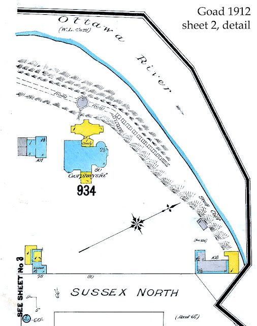

This view of 24 Sussex (then #80 it would seem?) is dated 1912 and gives us an idea of what the property looked like when W.C. Edwards lived there. Note the out-buildings. The "Lodge" to the lower left is now gone. The small stone building next to the main house is actually a shed for the greenhouse that was here, truncated by the edge of the map. (The entire structure appears on Goad's adjacent sheet 3) — the building would ultimately be replaced by the P. E. Trudeau swimming pool.  The L-shaped building to the lower right remains to this day, now used as a gatehouse — its wooden deck, extending past the cliff, has been since removed, probably for the better.  The wooden porte-cochère, supported by stone pillars, is said to have been added at the same time as the turret. I don't know who built the back-yard conservatory, but again I suspect Edwards.

1921 — William Cameron Edwards died on September 17. Ownership of Gorffwysfa eventually (circa 1923) passed to his nephew, Gordon Cameron Edwards, businessman, lumber merchant, and Liberal MP. Gordon Edwards had previously lived at the corner of Charles and Mackay in New Edinburgh.
1943 — from the Ottawa Journal, September 16
"...A claim for $278,697 compensation for the expropriation by the Dominion Government of his Sussex street residence, "Gorphwasfa", has been filed with the Exchequer Court by Gordon C. Edwards. Some months ago the Government filed an offer of $125,000.
The property was first expropriated, according to the Government's explanation, to prevent its being used commercially..."
1945 — from the Ottawa Journal, September 4
"...The former residence of Gordon Edwards, at 24 Sussex street, [was] expropriated this year on [a] ... settlement of $140,000, and reported to be used as the future home of Canadian Prime Ministers or as a guest house for distinguished visitors to Ottawa..." 
1946 — On Saturday November 2, Gordon Cameron Edwards died suddenly at his home, 24 Sussex. The house and its four-acre lot effectively passed into the hands of the Canadian Government. In 1947, Australia assumed a brief lease on the address, to serve as that country's High Commission offices. In 1949, Liberal Minister of Trade and Commerce C.D. Howe announced that the property would indeed serve as the Prime Ministers' Residence after some "refurbishment."
   Thus endeth our chronology.


   The above photo appeared in Maclean's magazine, which in turn credits it to the Ottawa Citizen, 1950, though the actual date of the capture is unclear. Note the wistful Red Ensign drooping in front of the porte-cochère. This is perhaps one of the last, few, clear, close-up views of old Gorffwysfa prior to the great renovation.  It's hard not to love all the sticking-out Victorian bits. One can picture Hannah Currier leaning out from the third-storey oreil, waving a handkerchief and shouting "Yoo-hoo!" to lord-of-the-manor Joseph C. as he paces the front yard,
digesting his dinner. But that was then.
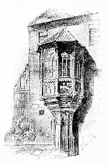
an oreil, Nuremburg

   The renovation (at a cost of nearly half a million dollars — figures vary) was completed in 1951. The new design retained much of the house's structural underpinnings, but the interior was fairly gutted and many of the sticking-out bits were lopped off to achieve an austere, Romanesque (bleakly Norman!) appearance. The house's footprint was extended northward by a two-storey side extension  (which some people call the "east" side — this being Ottawa.)

   It was in this edifice of restrained opulence that Prime Minister Louis St. Laurent took residence. We are told that he was not fully at ease with his sprawling new digs and insisted on paying rent.
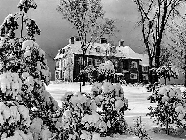
almost cozy — even Malak Karsh couldn't get a clear shot
   The rest, as they say, is history. Or rather it was until Stephen Harper moved out in 2015. Some 67 years on, the new, renovated 24 Sussex is old again, sitting empty, cold, and in sore need of extensive and pricey repairs.

 *     *     *
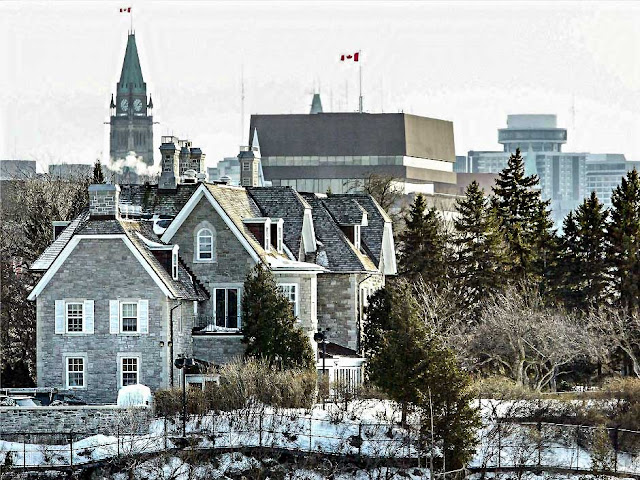
Now is the Winter of our Bleak House, via the National Post
   I'm returning to this POV, as it pertains to three photos from the very early 1900s. Indeed, all the above historical blather has been assembled to provide some perhaps unnecessary context for the charming images which follow.

   James Ballantyne (1835-1925) was a businessman (Ballantyne Coal), local politician and champion of education, often described as the Father of Ottawa East. You can read some biographical notes about this "Renaissance man" here. Ballantyne was an avid naturalist and photographer. Many of his pictures record daily life in and around "Old" Ottawa East, but he also loved to take his friends and family on picnics and nature hikes, camera at the ready.

   It was Kady O'Malley's comment about early images, few and from afar, that reminded me of something I first saw a year or two ago.


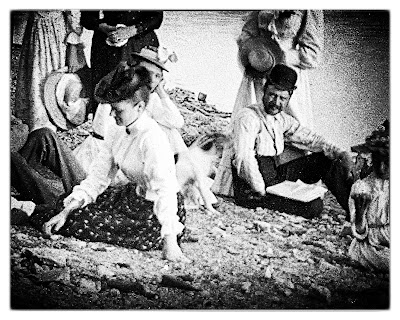
   The Library and Archives Canada (LAC) attributes this photo to the James Ballantyne fonds and describes it as a "Group photograph taken during a picnic 1891." The picture would have been taken either by James  himself, or by his daughter Mae.

   We may have to quibble about the date, but the location is beyond question. Anyone familiar with Rockcliffe Park will recognise this as the limestone escarpment overlooking Governor's Bay, with Gorffwysfa perched on its promontory in the upper left of the picture. Ballantyne's picnic crew have been posed partway downhill from the (now) Ski Hill lookout, framed by a break in the trees.

   (And if I've been harping unfairly about the inconvenience of trees, I should mention that some of the Eastern White Cedars growing on these cliffs were already mature trees when Samuel de Champlain's canoes first passed below them in the summer of 1613. Respect is due.)

   Keep your eye on the woman in the dark dress, standing second from the left. We're about to meet her again.


    Here she is, sporting a floppy sun hat. The group has climbed down the escarpment to the beach along the north shore of Governor's Bay. We recognise several people from the previous photo, including the gent with the bowler hat and suspenders, pretending to read his newspaper. I can't quite tell if his gaze is directed at the photographer or toward the young lady in the black hat. The young girl, bottom center, ponders the universe in something round, and someone else has brought an oversized oar that won't be of much use for paddling that canoe.

   Look at the building across the bay — the one on top of the cliff...


 ... 'tis fair Gorffwysfa, seen from afar. If you've noticed that window arrangement of the north facade doesn't match the modern view, that's because the 1950-'51 north extension hasn't been added to the building yet.  I'm not 100% about the smaller building to the right, the one with the dormers set in a mansard roof, but I take it to be the roadside "Lodge" on the southeast corner of the property. This is 24 Sussex as it appeared after Joseph Currier had died but while his widow still lived in the house.

   Now there's a wee cock-up on the dating of these photos. LAC gives a date of 1891 to the clifftop group shot, but sets the beach scene in 1893. A quibble perhaps, but it a bit of question when we consider our third picture.


   Was this an afternoon outing — or a weekend extravaganza?! I count three tents, one pavilion... and a wood stove! Oh, and those oars again. Are they for racing or what? The woman in black is back, seated at the center of the group. And those young ladies are playing lacrosse in the road. The location, to my eye, is halfway down the south-west side of Ski Hill — the curving slope on the left is signature.

   I have no doubt that all three images depict the same weekend outing. But in what year? The date bears on the question of how the bloody hell did Ballantyne haul all those people and all that stuff into the park from his home base at Main Street (just south of the CAR tracks, now the Queensway.) A wood stove for crying out loud...

   The electrified "cars" didn't begin running on Sussex until the first week of August, 1893.  So if the picnic took place in that year, the picnickers could have ridden the streetcars as far as 24 Sussex, then descended on foot into the park by the primitive dirt roads that serviced the area back then. I doubt that they would have taken tents with them, let alone a stove. Those items would have been brought in on horse and buggy, presumably loaded and unloaded by the men. If the picnic was held two years earlier, then everything and everyone was likely brought in by buggy.

   Either way, the woods and cliffs past the end of Sussex were still rather rough around the edges. Still recovering from lumbering and sporting two quarries, a sand pit, a marl pit, a clay pit and, somewhere, a lime kiln, the taming of Rockcliffe would properly begin on a Thursday, May 3 1894, when the park officially opened. That weekend, streetcar service began taking day-trippers from the city into the very heart of woods, where a designated meadow clearing provided refreshments, live music, an electric merry-go-round, and a grassy lawn ready to receive everyone's picnic blankets and baskets.

   James Ballantyne and his crew were either one or three years ahead of the madding crowd. They cooked their own food and made their own fun, roughing it as they saw fit — whether exploring the cliffs, canoeing, reading newspapers, or girl-watching. And Ballantyne was probably the first photographer to take advantage of a sight-line from Rockcliffe Park to 24 Sussex still used to this day.

Friday, 10 March 2017

Open Wide

198 Gladstone, south side, between Elgin and Metcalfe

   No, really, it's the pole.

   My last post tried to make sense of what happened to the north side of Gladstone between Bank and Elgin that made it look the way it does today. I'd like to think I did a passable job of barely scratching the surface.

   My claim that the avenue was widened between 1960 and 1965 was based on four pieces of evidence, all gleaned from the Ottawa Journal. First came this short article dated February 11 1960.
Widening of Gladstone avenue from Bank to Elgin street will begin April 30, City Solicitor Medcalf said today. The street will be widened 30 feet on the north side. The project will cost the city about $450,000. There are 26 properties affected with 64 housing units. Many of the people have been moving out since January.
   A lengthy article from October 1961 discussed downtown traffic congestion and included this snippet, quoting then traffic director Thor Nielsen.
...This would necessitate a ban on downtown street parking, more one-way thoroughfares and widening or improving roads. However, here wouldn't be too much road-widening done because of the prohibitive costs. The city today is spending close to $600,000 to widen a relatively small section of Gladstone Avenue — a lot of money spent on property acquisition...
   The next mention would take the form of a photo caption (May 28 1965). A messy view of Gladstone, looking east from Bank bore this explanation.
A $200,000 project to widen Gladstone Avenue from Bank Street to Elgin Street is well underway. That section of the Avenue, an old one-way narrow lane, is to be widened to 44 feet, which would allow for four lanes. The widened three blocks are expected to be ready in mid-July.
   Finally (and right on schedule) the July 21 1965 edition of the Journal would announce that...
...Reconstruction and widening of Gladstone Avenue between Bank and Elgin Streets is now complete and the street will be open for two-way traffic at 10 a.m. tomorrow. The street, very narrow prior to the $200,000 widening project, has been one-way eastbound in the past...
   I know, those little inconsistencies make my head hurt too.

   It's not often that the cost of a city infrastructure project drops by two-thirds over the course of five years. Perhaps the bizarre cost under-run indicated by the 1965 articles appeared because the project was divided into separately budgeted phases. Or did those later quotes fail to include expropriation costs? I can only guess.

   Also, how does widening a 30-foot wide road by 30 feet yield a 44 foot wide road? I can only blame sidewalks — they're long, flat and unpredictable. Indeed, the sidewalks on Gladstone were themselves recently widened, narrowing traffic flow between Bank and Elgin once again.

   What remains important is that the three-block widening of Gladstone began in the spring of 1960 and ended in the summer of 1965, during which time certain widths of land were cleared and various monies spent.

   And this raises a bit of a temporal conundrum.

   We've seen how a project executed in the 1960s occasioned the clearance of properties along the north side of Gladstone. So how can it be that this very stretch of road feature three substantial apartment blocks, sitting in perfect alignment with the widened road, but built in the early 1930s?  Consider the buildings labeled 2, 3 and 4 in the aerial photo below.

It's an acre, trust me.

(A and B on the image are the twin blocks of the Metcalfe Terrace apartments, C is Blair House.)  

   The six apartment buildings bounded by the yellow box were built some three decades before Gladstone was widened.  Their names and addresses, for the record, are...
  1.  333 Metcalfe, the Chamberlain (a significant name as we shall see)
  2.  335 Metcalfe, the Trafalgar
  3.  221 Gladstone, the Glademere
  4.  215 Gladstone, the Bessbourgh
  5.  252 Frank, the Aitken (formerly the Labelle)
  6.  250 Frank, the Victoria.
   All six buildings were built in the first half of the 1930s, They rise three storeys above their basements and all are finished in brick. The Metcalfe Street addresses sport Art Deco faux-sandstone accents and door treatments. The Gladstone buildings are more perfunctory while the smaller pair facing onto Frank Street share their own, less modernist charm. The fact that the east sides of the Bessborough and the Victoria are flush strongly argues that all six apartment buildings were built on what was once a single plot of land, occupying a single acre, sitting at the southern edge of Ottawa's original city limits.

another "Chamberlain House" — NW corner of Metcalfe & Lochiel (now Frank)

   Chris Ryan has written an excellent history of these buildings, and his research vindicates the "single plot" theory. The land originally belonged to Edson Joseph Chamberlain (1852-1924), general manager of the CAR and eventual president of the Grand Trunk Railway. Chamberlain built himself a beautiful, 15-room Victorian brick house on the property (lower center of above image) surrounded by gardens and trees — indeed, the trees made the house almost impossible to photograph! In 1929, some five years after Edson's death, the Chamberlain estate sold the property to a local developer, Wolf Shenkman, who planned to build a large apartment building on the land. However, as Chris explains...
... Ottawa’s plan to widen Gladstone avenue ... served to delay Shenkman’s project. The specifics of the then prospective widening of Gladstone between Elgin and Bank had not yet been settled in 1929 and the Board of Control decided to hold off issuing Shenkman a building permit. It would not be until November 1930 that the expropriation plan had been solidified and the Board decided that it was safe to issue Shenkman a building permit, so long as it would not interfere with the widening plan. In the meantime Shenkman’s vision had become considerably more significant: rather than the “large apartment house” he mentioned to the Journal‘s reporter in 1929, a total of six buildings would be erected on the site. The Town Planning Commission approved the subdivision plan on June 5, 1931 ... [my emphasis]
   Back in 1930 the plan to widen Gladstone seems to have been fraught with urgency, but as we have seen, this magnum opus would simmer at the rear of the city's athanor for three full decades before being realized. I would have to guess that between the Great Depression and WWII, peoples' priorities lay elsewhere. No matter, Shenkman built his apartments as if Gladstone might be torn up at any minute. The largest of the six would bear the name of the original property owner.

   This is where the sacrificial lawn came in — or that's how I like to think of it. Not a precinct of brazen Molochs, but a simple strip of curb-appeal running the length of the south side of the property. Here it is in 1958 — I've even coloured it in as I need the therapy.


   The idea was simplicity itself. Festoon the front of the buildings with an inviting expanse of green, knowing full well that one day it would be paved over — whether in 1930 or 1960.  Temporal weirdness resolved.

   Of course, the motley cluster of houses directly to the east of the Chamberlain property would have to be razed. Can't be helped, must be done... and so they were, soon after this picture was taken.

*     *     *
  If you look closely at the above image (click to enlarge) you'll notice a house with a little yellow X on its roof — it's near the right-hand edge of the picture. That's the house whose portrait appears at the beginning of this post, 198 Gladstone. Being on the south side of the street, it was spared the worst traumas of the Great Widening. You can see that it was originally one of two identical houses, both pleased as punch to be showing off their matching gambrel roofs.

   #198's concrete foundation tells us that it's not one of the oldest houses on Gladstone. The lot had first been taken up by a cluster of sheds, making eyesores of themselves when Edson Chamberlain was still living across the street. The little house has no bearing on this story, I took its picture because it was there. And if it looks crooked, please, blame the utility pole — they're never straight.

Monday, 6 March 2017

Rear Views

   The two blocks of Gladstone Avenue between Metcalfe and Bank share an odd trait in that their north sides are mostly bereft of houses or store-fronts. Apart from the sides of those buildings sited at intersections, this strip of properties displays the backsides of an assembly of late-Victorian and Edwardian houses, as well as those of more recent apartment blocks, all with Frank Street addresses. Here are two of the houses, seen from behind.

306 Frank Street. rear view
314 Frank Street, rear view

   Were they viewed from Frank Street, both buildings would present well-groomed red brick facades. Their derrieres, assessed from Gladstone are a shamefully different matter.

   The above pair of houses is bracketed by #s 322 and 292 Frank, of similar vintage but with backyard annexes reaching back to touch Gladstone's north sidewalk. Here is how Goad depicted all four houses 292, 306, 314 and 322. on the 1912 reprint of his Ottawa fire insurance map, sheet 67. I've shaded those houses and their immediate grounds in pink.

Goad, 1912 reprint, sheet 67
  
   Consider the street widths described. Metcalfe, McLeod and O'Connor (not labeled, to the left) are all 60 feet wide. Frank Street is a bit narrower at 56 feet. And Gladstone? At a piddly 30 feet across, it was at best the de facto back lane for the Frank Street homes, with a row of smaller, cheap and wooden houses on it's south side.

   I've drawn the red line cutting through the block to show the present north side of Gladstone (including the sidewalk, as best as I can tell.) This widening (between Bank and Elgin) began in spring of 1960 and was officially completed by July 22 1965. Expropriations seem to have made up the greater part of the project's costs.

   The four Frank Street properties highlighted on the map lost half of their back yards. 292 and 306 both lost out-buildings, Perhaps the most dramatic impact was felt at 322 Frank, "The Franconna."

   Built in 1903 by Robert Hurdman, the Franconna had a large, boxy, four-storey rear annex imposed upon it early in the 20th century. This discordantly modern appendage doubled the footprint of the original building and likely more than doubled its rentable floor-space. The annex reached right back to the northern edge of the old, 30-foot wide Gladstone Avenue. When The Widening was announced, the Franconna's owner opted to have the southern half of its annex chopped off and re-walled, resulting in one of the oddest looking apartment buildings in Centretown.

   As for the two houses in my photos, 306 and 314 were forced to choose between either smaller back yards or garages. The latter prevailed — their oft-repainted doors are choice targets for taggers, out for late-night, beer-fueled fun.

Monday, 30 January 2017

234 O'Connor Street

234 Cooper seen from Somerset Street W.

   From "Application to demolish 234 O'Connor Street, a property designated under Part V of the Ontario Heritage Act and located in the Centretown Heritage Conservation District" (full document here)
"The building at 234 O’Connor Street is a two-and-one-half storey, wood frame, brick clad structure with a front gable roof. It is located on the west side of O'Connor Street between Somerset and Cooper Streets. Based on fire insurance plans, the building was initially constructed between 1879 and 1901 with two, two-storey additions. It is identified as a Category 2 building in the Centretown Heritage Conservation District (HCD). The upper levels of the building were damaged by fire and it has been vacant for approximately 15 years. There is a parking lot on the south side of the building..."[The parking lot comprises two lots, 236 O'Connor and 311 Somerset West.]
   From 13 October 2016 Ottawa Sun article by Matthew Pearson (full article archived here)...
"The city's built-heritage committee on Thursday denied a developer's request to tear down a vacant house in the Centretown heritage conservation district.
Gemstone Developments wanted permission to demolish the red-brick building at 234 O'Connor St. and replace it with a temporary park...

Committee members considered two separate structural assessments — one submitted by the owners and one conducted on the city’s behalf. The reports identified similar issues but offered differing opinions on the extent of the damage. The owner’s report ultimately called for demolition, but the city’s report, prepared by John G. Cooke and Associates, concluded the building is “reasonably repairable.”
That's the same position the heritage department and Somerset Coun. Catherine McKenney took.
Gemstone only purchased the building about a year ago, but McKenney said the building had not been properly maintained long before that. "It may not be your neglect, but it is demolition by neglect," she said.

The committee's vice-chair Barry Padolsky said he supported the staff recommendation reluctantly because the city has done very little to address the building's deteriorating condition over the years..."
   In our photo, the belfry of Dominion Chalmers United Church peers above #234's roofline. In the distance and to the left, the ghostly, Carrara-clad towers of Esplanade Laurier mark the skyline while to the right, Plaza 234 (the "old" EDC building) shows off its stripes*.

adapted from Goad, January 1888 sheet #53

   Goad (1888) shows 234 Cooper (which I've highlighted in pink) completely built, including the two rear extensions and a small detached shed. Both houses directly to the south have since been demolished.

   An early (likely the first) resident of the house was one Colin Dewar (Might, 1901) a bookkeeper with the Ottawa Water Works Department, this at a time when that office's duties included sprinkling the streets in summer to keep the dust down to a dull roar.

   I can find no more recent discussions of significance — #234 quietly awaits its fate.

*An earlier version of this post misidentified Plaza 234 as Place Bell. I must endeavour to sniff less glue on weekdays.

Saturday, 21 January 2017

326 Somerset Street West: Chamberlain House

the House with the Turret

  The 1884 City Directory lists no homes on the south side of Somerset between Bank and O'Connor. The house above does appear on Goad's 1888, sheet 53 as a solid brick building numbered 352 328 (eventually 326.) While this might suggest that it dates to some time between 1884 and 1888, a plaque on the house reads (source)...
1894
Chamberlain House
First occupied by David G. Chamberlain
Civil Servant

   Whatever. The source cited above also tells us that...
"This is a two and one half storey brick house of the Eastlake* model of the Queen Anne Style. The property on which the building is situated was part of the estate of John By, which was one of the most important parcels of land in the development of 19th century Ottawa.
D.C. Chamberlain, was an accountant with the House of Commons, lived in the house until 1901 when he sold it to a relative, Hiram W. Chamberlain.
Reference: Some early Ottawa Buildings, by C.J. Tayler, Historical Research Section, Canadian Inventory of Historic Building. 1975"
   The Might Directory agrees that a Hiram W. Chamberlain did live at (then) #328 in 1901.

   If anyone is wondering why parts of Centretown and Sandy Hill are thick with these red-brick "Queen Anne" houses dating to the reign of Queen Victoria...

   There was indeed a Queen Anne, whose short reign spanned the years 1704 to 1707, well before that of Victoria. What we call "Queen Anne Style" — this massing of bays, dormers, overhanging gables, fancy woodwork and yes, turrets — is supposed to mark the revival of a whimsical style popular in the early 1700s. Except that houses built in the revival style don't look all that much like actual Queen Anne architecture. Go figure.
  
   And yes, that's a wee "For Sale" sign stuck in the snow by the tree. Royal Lepage describes #326 as a "STUNNING VICTORIAN OFFICE BUILDING, CAREFULLY RESTORED AND UPGRADED..."(caps theirs), listed for sale at $1,495,000.00. 

   This block of Somerset (between O'Connor and Bank) features several of these late-Victorian houses, now serving as offices, pubs, bistros, hair salons and the like, collectively calling themselves "Somerset Village" for the purposes of tourism and real-estate. 

(go get 'em Getm!!!)
  
   If you're heading west, you'll know you're leaving the Village when you see the thing that looks like an elephant's backside painted orange.

*     *     *
*Not a body of water but Charles Eastlake (1836-1906), an American architect who gave us his own particular spin on the Q.A.R. style.

Friday, 20 January 2017

(another) Bate House

46 Cartier, viewed from the SE corner of Cartier & Somerset

   This crapulent weather may be depressing, but gloomy skies totally rock for picture-taking. After ten years of flicking graff, you learn to hate hard shadows. Hard shadows are where things go to die.

   We were rubbing shoulders with a "Bate houses" a post or so back. C.T. Bate built at least one, and probably two (or more) houses in Centretown while his better-remembered brother Sir Henry Newell Bate built several of his own, mostly in Sandy Hill. C.T. seems to have had an eye for all-stone baronial architecture while H.N. favoured the timely asymmetries of the late Victorian "Queen Anne Revival."

   My interest in the Bates goes back to last year when I spent a few days researching the ancestry of my best friend from high school, a descendant of Sir Henry N.  I discovered that his (my friend's) grandmother's house on Wilbrod (cue the ferns) was but one of several attributable to the man.

   Indeed, I tripped over 46 Cartier while looking into another apparent "Bate house" — a murky sprawl one block further south, on the NE corner of Cartier and Maclaren. Searches on "cartier bate" made it clear that #46 is the better documented. Also, it's not hidden behind a screen of Manitoba maple. I'll get to the house at Maclaren eventually. At some point soon I'm going to have to assemble a catalogue of these buildings.

   Robert Smythe composed a historical sketch of 46 Cartier in the summer of 2014. He tells us that the house...
"...was built for Newell Bate in 1901 — likely an early work by W.E. Noffke. It was later the home of New Brunswick Senator Geo. W. Fowler, and between 1924-42 the residence of Supreme Court Justice Thibodeau Rinfret. From 1942-65 it was the D'Youville Convent, then a nursing home, a bed and breakfast [Carmichael Inn and Spa], and most recently the Embassy of the Syrian Arab Republic." 
   Read his entire article here. Smythe goes on to discuss St. Theresa's Catholic Church (1929, directly across Cartier from #46) and the astonishing "Seybold's Castle" (1890s), the sandstone folly that predated the church.

46 Cartier, south side as viewed from Somerset

   A plaque affixed to the building reads...
“This fine example of the houses constructed for Centrertown’s affluent residents was built for retired merchant Newell Bate. The elaborate chimneys, porches and gables clearly identify the building with the Queen Anne revival style.”
   The Global Affairs Canada website continues to list, 46 Cartier as the home of the "Embassy of the Syrian Arab Republic." However, a blog post (2-Dec.-2015) by Jeremy MacLaine titled "The Abandoned Embassy of Syria in Ottawa" indicates that...
"Syrian officials were booted from the embassy in May 2012, when Canada joined the US, UK and several other European states in the decision to expel Syrian embassies and consulates as well as staff."
   MacLaine claims that the house is in a state of disrepair, it's grounds (as of late 2015) strewn with garbage, despite the building's 1994 heritge designation. He also points out that this embarrassment stands a mere block from City Hall. I can't say that I noticed any striking maintenance issues with the building, but then I wasn't looking for them and the grounds are presently covered by snow. It is not clear to me who presently owns the property. A Syrian flag, limp and sodden, still hangs from the flagpole and security seemed non-existent.